
Bushwhacking is, broadly, the practice of going cross-country, instead of always following roads and trails. The term is a backformation, to create the action a bushwhacker often performs. Many like to say that this is all derived from the way you move through the woods off trail, hitting (whacking) branches to get them out of your way but that's a terrible way to get through the woods.
Instead, it's most likely an inherited word, from something like the Dutch bosch wachter meaning a "forest keeper," in the sense of a game warden, groundskeeper etc but back when people owned whole forests.
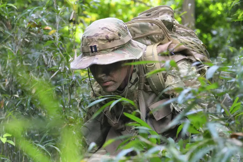
People familiar with the woods, and who become comfortable operating within them, do not stick to roads and trails, but are able to go anywhere, cross country, picking the best route through even literally trackless wilderness.

Why does it matter how you get there?
I or others have often brought up road movement with students while moving, or in AARs as being a bad thing, only to be challenged. Does it really matter? We got the mission done, after all.
Well, remember that in much training we're not so full-spectrum. There aren't always ISR platforms, ground sensors, and land mines. To get the focused training done on time, proving that your road movement is dumb with even just an ambush would be counterproductive as we'd have to reset everyone and start the lesson again. So it can sometimes be hard for everyone to understand the risks they are taking.
It is not just direct risks to your team — being detected and then ambushed, attracting fires, or simply triggering land mines / IEDs — but broader problems of exposing yourself to enemy observation. Simply being seen in an area can reveal information about the current disposition of your unit, and future plans your leadership has.
Roads, Trails, Paths
Road travel is always limited, and especially dangerous for tactical purposes, but each tier of road has it's own unique purposes and risks.
Note that in all cases I am talking about tactical use, not operational; if you are walking along with thousands of others as the whole Brigade rolls down a road, there's little risk to your fire team individually.
I also am talking for this whole article about generally temperate zone stuff below the treeline. We've done lots of off-trail stuff in arid regions in the Mid-East and North Africa the past 20-30 years. These are very different environments, especially for the benefits and risks of each.

Roads
I classify all roads the same. Anything designed for vehicle traffic of any sort from trucks to jeeps to bicycles is "a road." Higher traffic and higher speed roads generally have more of the problems but they are the same class of problem. Namely that roads are relatively straight, clear and unobstructed, and generally have no overhead cover so are nearly impossible to move down without being seen. A very twisty vehicle road has sight lines often hundreds of meters long. Highways may make you visible for miles.
They also have drainage, bridges, cuts and fills, and otherwise are often hard to get off rapidly and into cover even if the surrounding terrain otherwise has any to provide.
However, roads are often unavoidable. There may be no other way through an area, such as for river crossings, marshes or flooded fields, large rivers, or other impassable areas may only be conveniently crossable — without other equipment such as getting boats — without using the road.
Roads in very high threat areas are not just mined, but often are very heavily mined in margins and drainage ditches because they would otherwise be ways to mitigate the visibility. This is why we all know the drill to cross roads; that is a hint we should to that more, instead of traveling down them.
Railbeds
Railway lines, whether live, disused or abandoned are often also useful and necessary, or inviting to use. They are even worse than most roads as they are always very very straight (trains don't turn tightly), and are cut and filled even more, with many more bridges, again because trains can't climb steep slopes or turn tightly. The roadbed is raised for drainage, and it is hard to travel on or adjacent to the roadbed due to the gravel ballast that the track is laid on.
Despite the risks, all those bridges, cuts, and even tunnels can often be advantageous. A rail link may be the only way across difficult terrain without very long delays or very long movements so may be worth the risk as for roads.
This is also a good time to mention that some stuff has changed over the decades. WW2 era guides on using roads and rails are outdated as standards of construction and technology have changed. Railways, for example, have many fewer signals, and do not store as many tools locally, so there are not 10% of the sheds and piles of spares. There are also increasingly few telegraph lines and those that remain are derelict, so you can no longer hijack them for your field phone.
Trails
Trails, unlike roads, are only for foot traffic. You might find bikes or even carts, but they will at least in part have to be walked or pushed. Trails may be bumpy, steep, have sharp turns, and may even be impassable part of the season.
However, foot trails are the primary way of moving people and goods in much of the world still. There are still — formal, and with signs the government maintains — foot trails in parts of Europe and the UK, separate from the road network.
These are well known, and while they often go through scrubland or woods so visibility is lower than open roadways, they are often improved over time. They may have long straight stretches, bridges and other areas of long-distance visibility. Being well-known means they are often mapped, and always known to locals so may be full of traffic, which slows movement as well as letting everyone in the area know you are there.
Of course, as with all predictable paths, this also exposes you to ambushes, though on well travelled routes you can often avoid mines by following locals or carefully inspecting the ground to see where they have gone off trail briefly for un-obvious reasons.

Goat tracks
At least as I was raised, natural trails — sometimes beaten in by people but short of actual real trails — as well as actual animal trails, are called goat tracks. Even animals naturally gravitate to trails! These are useful in that they are trails and so go somewhere, mostly reasonably efficiently, and when in the woods can be very hard to find from the air, or by enemies that stick to trails themselves and so on.
They will often be much slower to travel on than other trails, and can be loud, as well as presenting significant risks for night travel. Animals either are often shorter or being quadrupeds can bend down more easily so branches at standing height will be in your way, and you have to go around or crouch down regularly to traverse a goat track.
Goat tracks are made by walking through the woods repeatedly. They are what happens when you bushwhack over the same ground too many times, so watch for that yourself; think if the same route over and over is the best plan or a giveaway.
Those you encounter are often shared by the local wildlife and population, but also split and join up constantly. Why? Because a boar can fit down a track much shorter than a deer, and may want to go different places for their forage or rest. You probably want to go none of those places, so be careful selecting goat tracks for your travels.
In addition, they are still trails. They can be seen with sensors, which is bad for being found but good for you to pick them out with thermal or night vision. Goat tracks can be fairly easy to follow at night with NODs, as long as you don't get off trail.
Of course locals or enemy who have saturated the area will already know all these as well, and can plan for you to use them, or even lay ambushes. Mining is less likely as it will be ineffective if animals currently use the trail, and set them off all the time but there are ways around that, so it's not to be discounted entirely.
Rights of way
A trap many fall into when going cross-country is making things easier by using once-cleared areas like rights of way. The space under power lines, or over pipelines, for example. However, even old ones are on maps, or known to the locals. They are again predictable, so expose you to risks like ambushes.
They also often are harder to traverse than they seem at first, as they are cleared of tall trees so those not taken over by grasslands are entirely covered with brush and scrub; depending on where you are, this may be very hard to traverse.
In addition, rights of way are straight and the lack of tree cover makes you visible from long distances and from the air. Rights of way are a trap, not a trick, and should be treated as linear danger areas, to be crossed carefully, not traveled down.
Bushwhacking
Cross country travel is very often the best way to get somewhere, for the opposite of all the reasons above. It is unpredictable, so impossible to lay detailed ambushes or set mechanical obstacles (though large area ones can be set, across a whole valley for example).
Dense forests are the best, as they provide the most cover, the greatest benefit. But they are very different environments than hiking down trails in dense forests, than open grassland or scrubland. You will go very slowly, can be very loud, and can easily get lost.
Yes, you can easily get lost in a few hundred meters of dense trackless woods, and completely end up going in circles.

Sun, trees, and verges
Why are woods good to hide in? I mean we assume that they are good, and some things like overhead cover are obvious but why else? Darkness.
Woods have trees that make the forest floor darker. This means if you stand inside there, you are darker than the outside. In addition, the verge (the transitional edge of... pretty much anything outdoorsy) is protected from the worst storms such as damaging winds, but has more light, so is almost always very overgrown. Looking through this into even the only slightly darker forest beyond can make you nearly invisible. This is why you set OPs and sniper hides in such places, crawling into the brush at the edge or cutting then erecting netting, to see but not be seen.
Much the same effect can be gained when walking through the woods. A bit less so with modern sensors, such as thermals and radars. The darkness doesn't impact them, but the broken image — more broken, more concealed the further into the woods you are — makes it hard to detect and track you, and hard to identify even if a return is seen.
Note that anywhere there is light there will be additional growth, so you will need to work through the overgrown verge at clearings and even around open water or wide enough rivers. Plan your movements accordingly, and look at the type of vegetation you can expect, avoid moving in and out of open areas, and if you need to access a pond make plans for how to get to the bank.

Moving cross country
I mentioned up top you don't whack the bushes when moving cross-country, so how do you move? Around things. One thing I notice when bushwhacking is my neck gets tired, as I don't just scan for enemy left and right, but also look up and down a lot. Down, to make sure you step somewhere reasonably clear, instead of on a branch that will crack, a rock that rolls away, or through a thorny bush. Up — well, level — to assure you can fit your body and pack through and under the branches.
In much of the world you can just run headlong through the woods, but there are areas such as many places near me, where there are thorny vines that tangle, and entire 10 foot tall brambles that will stop you no matter what. Do not try to muscle your way through the woods, but be smart, and careful instead.

Moving as a team
You will further want to really, really lean into all your land nav and patrolling tasks for the whole team. Point is just point, second is compass, then somewhere back there you have backup compass, a separate GPS/ATAK guy, a pace counter, and so on. Everyone has very clearly defined zone to scan, and must stick with it.
You will usually need to travel in a single file. For all the usual reasons, of reducing frontal area from detection or unexpected meeting engagements, to conceal numbers for those you bump into, but also due to the expected difficult terrain. You will find and use one path through the woods, and only one, leaving the smallest impression that you were there. As the terrain gets more difficult, and as it gets dark — even with night vision — close up ranks, all the way to being arm's reach apart. Even in daylight, if the terrain is bad enough, being able to immediately help each other from falling, or climbing or so on, will often be more beneficial than being spread out to reduce casualties in an ambush.
Naturally, you will move to other formations as needed. Not just as you move to roads, open fields, or into attack, but even simple things like cresting a hill, you may wish to spread out a bit (if not put the whole unit on line) to give a greater chance to observe the enemy first and bring fire to bear. Or, not, if you need to remain sneaky above all. It depends on the mission, but single file is going to be the default, and that will impact how rapidly you can move people across land and into an objective.
Remember to work as a team. Help each other out over obstacles, hand off gear when tangled or someone will have difficulty climbing or traversing something. Simply turn around, and point to obstacles, hazards, or indicate the path forward.
As team leaders, take lots of listening halts. Don't be too gung ho, because you will wear everyone out, and miss opportunities to observe things. During these, re-brief everyone on the plan. Where we are going eventually, where we are now, and where are we going next. Point out any deviations from the original plan, either already done, or expected now you are on the ground.

Don't touch anything
Up and down
Speed vs sound
Water courses
Much like rights of way, water courses (streambeds, dry intermittent streams, or just drainages and swales) may seem like a good way to move cross country. They are generally clear of brush, go a predictable place, and are in a depression so you are further concealed from observation.
However, some of these are actually bad. They are predictable, so if a good route in, the enemy can see it and set OPs, or ambushes. Mines are hard to lay in such features, but especially off-route mines are not impossible.
They are often very loud; from splashing, or loose rocks, and leave signs of travel for anyone following or who crosses it. The reduced visibility of being in a depressed and twisty course means you will be surprised at trail and road crossing, and have limited options for addressing the new linear danger area as you are already constrained.
And the overall depressed area means an enemy that finds you, can easily maneuver on you without being seen, and position themselves to hold high ground. Imagine further you are traversing a long bend in a creekbed, and the enemy is positioned on the high ground inboard; they can bring you under fire for a long time, and for long distances as you try to escape the beaten zone.

The military crest
When I talk about following water courses I mean any low ground, as water runs downhill. But you must do the same for the other side, the crest or ridgeline of high ground.
Often there are trails along crests, as they are easy to navigate (going downhill to the side? You are wrong and can easily adjust) and provide a great view. So first, we're avoiding trails, right?
Even aside from the trail issues above, in the densest woods and the shallowest of rises, standing on top of it is more visible than not. The military crest is a somewhat complex concept that involves reducing the area in defilade (not visible to you) below and is mostly taught for setting OPs and ORPs and setting base of fire. But it is a key navigational tactic for cross-country movement that is not really ingrained enough. Most importantly for movement purposes is that you are at least 6 vertical feet from the top of the terrain feature.
6 feet because that's how tall the typical tall person is. 10 is safer, and easier to figure out. How is it you figure this out? We're back to land nav skills; you are gonna get very familiar with the topo maps and often enough they have 10 ft contours so, you are gonna walk one narrow brown contour line below the crest. Ideally, you won't stand there in the woods and count lines with a bit of stick, but will figure this out during the route planning before you set off. You should generally know how far off the crest to stay, and what other features to look out for.
Most areas share a common topography, so once you get the gist of one hill, you know all of them for at least a while. Also note when it will change, such as when you climb out of a river valley area or move from foothills to mountains. While long campaigns of course will change terrain, even within a small area, you may move from one type of terrain to another, and must understand that for lots of applications of terrain association, siting and concealment, as well as bushwhacking.
Natural lines of drift
The easiest path through an area is called the natural line of drift. Think of the way water flows through the path of least resistance. For a particular objective, considering terrain and obstacles, and for a particular way of moving. As a kid on your bike, riding through a drainage ditch to cut between your house and your friend's might have been a natural line of drift, because for your mode of transport it was the easiest way to get there. Same as highways for cars since driving back roads for hours is more tedious
As discussed, through the woods, you will go around brambles, go up and down the steepest slopes at angles, and cross creeks straight on. Natural lines of drift will be populated by goat tracks, but as I mentioned, these are not always useful as the path of least resistance for a fox is going to be different than that for a human.
Be aware of natural lines of drift, and think about how to use them. Casually hiking for recreation, or moving your squad with no threat, you should use these principles to make things easier and more entertaining. But moving tactically, to avoid detection? You should make deliberate choices to avoid the easy path, so your route is not predictable and you do not have meeting engagements with enemy forces not being so careful.
Use the same analysis of the terrain for setting bivouac sites, sentry posts, and OPs. Be able to watch over nearby trails and other natural lines of drift, but do not actually camp right on one, so no one trips over you in the night.
Reducing spoor
Okay first, spoor is too often used as a euphemism for wild animal poop. It is actually any trace at all by which the progress of someone or something may be followed. Anything. It is both a joke we make, and true that tire tracks are truck spoor, and so on.
You know most of this. Avoid walking through open muddy areas, or other places you will leave footprints. Don't cut down poles or firewood near camp. Carefully pick up your campsite — and listening halts — when you leave.
But when traveling, often people forget this. We break off branches to make travel easier, break or cut fences, and walk blithely through tall grass. Everything you move through and step on leaves a trace. Often, a very small one, but a field of grass or forest floor of leaves will absolutely show your path, if viewed at the right angle or with the right platform (it is really easy to see tracks from overhead, like aircraft and drones).
So how do you reduce your spoor? Well, my principle of going around instead of through it is part of this. Don't break branches. Consider spoor as well as effort when picking a path, so go around areas your footprints will disturb the forest. Skirt grassy areas, where brush or grass is shorter and won't leave an obvious trace.
There is a lot to this but the best thing is to be aware. Look behind yourself and see what you are leaving behind. Often a best practice is for one of the more experienced people to be trail (last is the line) so remind them to watch for this, and see how much trace you are leaving, then discuss how to improve it — as a team, and for the particular terrain — at the next listening halt.
Remember that much of the mystical nature of indigenous people knowing what wildlife is up to, or finding you easily, is simple familiarity with the terrain. Think of how small a change you would notice in your yard, or on the drive to work. To you it is just "a forest," but locals notice every tiny change, so don't leave any for them to find, and when you must then try to do it off those natural lines of drift where no one is looking.
The limits of not being seen
When using dangerously-obvious land — around a water course or a long ridgeline the enemy could guess — seems the best or only way out, try instead to use it as a handrail — a guide you keep at "arm's reach." You stay parallel to it, but somewhere hidden, such as halfway up (or down) the slope to one side. When possible, take shortcuts such as cutting across bends in a river, to shorten the trip and gain high ground to give visibility to threats you are approaching, or which may be stalking you. Cross ridges not at the center of a saddle, but well up it, keeping the whole area in sight to avoid or flank and surprise enemy OPs or ambushes.
But even that may be difficult. Very often you have no option but to walk hard against water courses, to cross high ground, or walk through a tall grassy area between them. As you move more and more into economically-active areas (whether housing, industrial, or agricultural) the only remaining woodland is that which is hard to develop, or banned from development, usually due to steep slopes, periodic flooding, and so on. The only woods though an area may be the verges along a water course, or a very obvious hill.
At some point, realize there is little value in trying to hide, and maybe you are making your life more dangerous. The enemy has eyes, and maps also. They will assume approaches of scouts and raiders through here, and take appropriate actions.
Always plan out your movements with the big picture in mind, thinking of risks, and ways to mitigate them. Plan them, or communicate this to higher command, before you get tied up in the minutiae about operating at the small scale, moving from tree to tree. Maybe it's best to just go on roads with trucks, maybe you need to go old school artillery barrages beforehand. Don't make assumptions of any one course of action or tactic.
Instructors, and leaders, must do better
As I said early on, the whole reason I am writing this is that people in the field are all too often deeply unskilled at walking through the woods, or so unfamiliar with it they never even think of simply cutting cross country. I blame a lot of this on instructional focus, and the reduced time most armies spend in the field.
When a whole afternoon is an abundance of time for a lesson, we cut corners. We get ride, and move down trails. We set the training site right off road, and practice our patrolling, observation or whatever it is, on road or trail.
While there's little to be done about changing the culture enough to get more training time, it is important we train like we want everyone to fight. If your expectation is having light forces, or scouts, then make a point of having everyone move cross-country — and properly, quietly, using all these techniques.
If you plan for it, and have permission depending on training facilities, it is often easy to add on small extra tasks to keep everyone sharp on these skills. For example, if you have three lessons to give, have them at different stations in the middle of the woods, then have the students use land nav and bushwhacking skills to move between stations.
These do not have to be long movements. In fact, frequent and bite-sized training is more effective than annual big exercises, much less Powerpoint days. Make sure the tasks you expect your students to perform are regularly practiced, so they become ingrained, and are used when really needed.